New York Public Library Picture Collection
New York Public Library Picture Collection |
SUMMARY:
This "real history" math problem is based on actual calculations of the size of the Connecticut Western Reserve before and after the survey - an estimate complicated by the fact that part of the grant was known to be under Lake Erie. How much land it contained depended on the slant of the lake shore, which could only be determined by an actual traverse.
Using a digitally generated base map, historical maps retrieved from the Internet, an archival primary source document, legal boundary definitions, and advanced students will draw in the land grant (an irregular polygon), explain how its area was estimated before the survey, and demonstrate how surveyor Augustus Porter arrived at his official calculation using information derived from the traverse. Younger students can construct the map, subtract areas, figure percentages and convert square miles into acres.
HISTORICAL BACKGROUND:
(NB: Some of the following will be delivered by animated maps and archival images on the internet.)
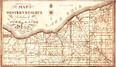
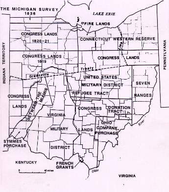
After the American Revolution, when the Eastern seaboard states were ceding their western lands to the national public domain, the state of Connecticut managed to keep a piece of her original sea-to-sea charter claim about the size of the mother state. Connecticut's "Western Reserve" was legally defined as a rectangle running between her extended northern and southern boundaries — north latitudes: 42 degrees 2 minutes (the International Line) and 41 degrees — for 120 miles west from the western boundary of Pennsylvania.
The westernmost 500,000 acres of the grant (later called the Firelands) were immediately set aside to compensate Connecticut citizens whose property had been burned during the American Revolution. The remainder, officially estimated at 3,000,000 acres, was sold to a group of Yankee speculators called The Connecticut Land Company. In order to stop the price from going higher through competition with bidders from outside the state, the Connecticut investors consolidated their interests and bought off their competitors with shares in an Excess Company speculation. The proceeds of the sale went to support Connecticut's common schools, but Indian wars on the frontier prevented surveys and settlement for several years. In 1795, the Treaty of Greenville established the western boundary of the United States as a line running south from Lake Erie along the Cuyahoga River, through the Connecticut Reserve, opening its Eastern portion, while leaving the western part, including the Firelands, in Indian country. A group of fifty surveyors and support crew went west in the summer of 1796 to measure and map this land. Gen.Moses Cleaveland of Canterbury, CT, a lawyer and land company investor, headed the survey team.
VISUALIZATION:
Screen the whole video or pick it up at the point where Moses Cleaveland is seen sitting on a camp stool on a bluff overlooking Lake Erie, answering the mail his men had just picked up in Pittsburgh while getting more supplies. One letter, from Cleaveland's father-in-law Henry Champion, takes us back to Connecticut, where the land company investors are growing impatient.
Because the northern boundary of their grant intersects the southern shore of Lake Erie, they know that some of the reserve is under water. A few early maps show the lake dipping sharply SW; others show it more or less horizontal. So until the land company can actually survey the shoreline, they can't be sure exactly how much land they have to sell. The Excess Company owns the right to any land that might be found in excess of 3,000,000 acres — and the Connecticut proprietors have agreed not to sell any of their own land until the actual area is known. By midsummer, a bidding frenzy for Excess Company shares is going on. Meanwhile, the CLC investors are unable to recoup their survey expenses through any sale of land.
In his letter, Henry Champion directs Cleaveland to run a traverse (i.e., measure with compass and chain) along the lake, even though it means crossing the Cuyahoga River in violation of the recent Treaty and trespassing on Indian lands. Cleaveland appoints chief surveyor Augustus Porter to head the expedition and do the calculation. Following is Porter's recollection of this journey.
PRIMARY SOURCE DOCUMENT:
— Excerpted from a memoir by Augustus Porter, published in the Buffalo Commercial Weekly, May 3 and 10, 1848.
PREPARATION OF MATERIALS FROM INTERNET: (3 team approach)
PROBLEMS:
HISTORICAL FOOTNOTE:
The Connecticut Land Company was not happy with this outcome — or with
the survey expense accounts. A Yale professor called in to check Porter's
figures determined them to be essentially correct. Cleaveland's expenses were
also grudgingly approved. Both men declined to go back to the Western Reserve
the following summer and, so far as we know, neither ever revisited the area.
Years later, computations made by adding up the individual township surveys
produced the following totals: 3,366,921, and 3,333,699.